<Terms and Conditions of Use>
●The City of Kushiro Web Hazard Map (hereinafter “this Website”) is a website that users can access on their computers and smartphones to browse predicted danger points, etc. for natural disasters such as tsunamis, flooding, and sediment disasters in the City of Kushiro.
●The support browser for this website conforms to the "Location Guide Service" provided by Zenrin DataCom Co., Ltd. Other browsers can be used to display this website, but some functions may be limited.
●The data on this site related to hazard areas, geographical features and political boundaries are schematized for public use and are subject to error.
●Maps and other map contents displayed in the background of this website are in accordance with the Terms of Use (Conditions of Use) for the Location Guide Service. Please note that map contents do not indicate land usage or land boundaries.
●The aerial photographs used on this site were taken by the Geospatial Information Authority of Japan. The Terms of Use for these photographs are in accordance with the Terms of Use of the Geospatial Information Authority of Japan.
●These terms of Use (“Terms of Use”) describes the terms and conditions applicable to your use of map Data ("Data") provided by this website (“Website”). Please be sure to read these Terms of Use before using Data. By accessing or using Data, you acknowledge that you have read, understood, and agreed to be bound by these Terms of Use.
<Tsunami Information>
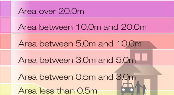
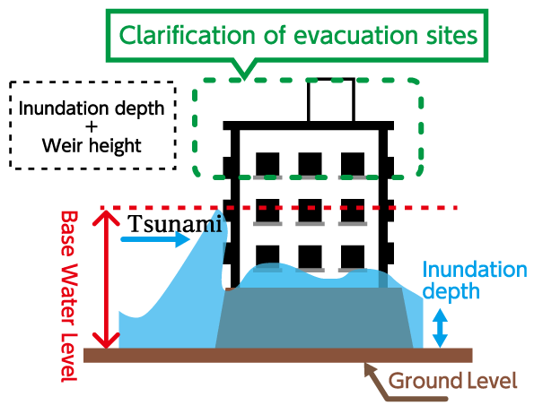
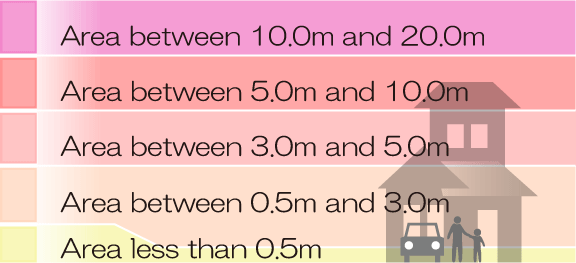
●The tsunami information on this website is based on the "Potential Tsunami Flooding Area" established by the Hokkaido municipal government in July 2021 and the "Base Water Level (the water level obtained by adding the height of the water when a tsunami hits a building, etc., to the assumed flood depth of the tsunami)" announced by the Hokkaido municipal government in March 2022, in accordance with the "Act on Regional Development for Tsunami Disaster Prevention".
<Information about Storm surge>
●This map was created based on the "High Tide Inundation Area Map" published by Hokkaido Prefecture in June 2025.
●This map shows the areas and inundation depths expected to be flooded by storm surges caused by the effects of the largest typhoons on record.
●This hazard map shows the areas expected to be flooded in the event of a maximum-level storm surge caused by a typhoon that is estimated to occur once every 500 to several thousand years. If a storm surge warning is actually issued, Kushiro City will release evacuation information, such as areas to evacuate and evacuation shelters, depending on the scale of the storm.
●Expected typhoon magnitude (probability of occurring once every 500 to several thousand years)
Central pressure: 950 hPa, storm radius: 75 km, moving speed: 73 km/h
*The assumed typhoon scale is calculated based on the Muroto Typhoon and the Ise Bay Typhoon.
<Flood Information>
●This Website does not show flooding due to unexpected amounts of rainfall, storm surge, or inland flooding, so caution is required even in uncolored areas.
●Please check the information below, which has been released by the Ministry of Land, Infrastructure, Transport and Tourism and Hokkaido Prefecture in accordance with the partial revision and enforcement of the Flood Control Act on May 20, 2015.
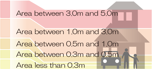
●The presumed inundation area is the area specifying the range and depth of inundation expected at the time of river flooding in the event of rainfall amount and flow rate of the maximum presumed scale.
The rainfall and flow rate of each river, upon which the calculations are based, are as follows.
[Shin-Kushiro River, Kushiro River & Beppo River Flood Hazard Map]
This hazard map is based on the "Kushiro River System Presumed Flooding and Inundation Area Map" published by the Hokkaido Regional Development Bureau in June 2016 and the "Kushiro River System Kushiro River & Beppo River Presumed Flooding and Inundation Area Map" published by the Kushiro General Subprefectural Bureau in June 2018, with the inundation figures in each area overlapping.
〇Presumptions
・Maximum scale: Presumed flow rate of 2,100㎥/s in the Shin-Kushiro River
(approx. twice the flow rate of the 1920 Kushiro River flood, the largest flood of the river on record)
Presumed rainfall amount in the Kushiro River and Beppo River: 387mm/24hr
(approx. twice the rainfall amount of the 1920 Kushiro River flood, the largest flood of the river on record)
・Planned scale: Presumed flow rate of 1,200㎥/s in the Shin-Kushiro River
Presumed rainfall amount in the Kushiro River: 186mm/24hr
[Shin-Kushiro River Flood Hazard Map]
This hazard map is based on the "Kushiro River System Presumed Flooding and Inundation Area Map" published by the Hokkaido Regional Development Bureau in June 2016.
〇Presumptions
・Maximum scale: Presumed flow rate of 2,100㎥/s in the Shin-Kushiro River
(approx. twice the flow rate of the 1920 Kushiro River flood, the largest flood of the river on record)
・Planned scale: Presumed flow rate of 1,200㎥/s in the Shin-Kushiro River
[Shin-Kushiro River & Beppo River Flood Hazard Map]
This hazard map is based on the "Kushiro River System Kushiro River & Beppo River Flooding and Inundation Area Map" published by the Kushiro General Subprefectural Bureau in June 2018.
〇Presumptions
・Maximum scale: Presumed rainfall amount in the Kushiro River and Beppo River: 387mm/24hr
・Planned scale: Presumed rainfall amount in the Kushiro River: 186mm/24hr
[Akan River & Shitakara River Flood Hazard Map]
This hazard map is based on the "Akan River System Akan River Presumed Flooding and Inundation Area Map" and "Akan River System Shitakara River Presumed Flooding and Inundation Area Map" published by the Kushiro General Subprefectural Bureau in June 2019 and March 2023.
〇Presumptions
・Maximum scale: Presumed rainfall amount in the Akan River and Shitakara River: 328mm/24hr
・Planned scale: Presumed rainfall amount in the Akan River and Shitakara River: 224mm/24hr
[Onbetsu River Flood Hazard Map]
This hazard map is based on the "Onbetsu River System Onbetsu River Presumed Flooding and Inundation Area Map" published by the Kushiro General Subprefectural Bureau in January 2024.
〇Presumptions
・Maximum scale: Presumed rainfall amount in the Onbetsu River : 360mm/24hr
・Planned scale: Presumed rainfall amount in the Onbetsu River: 165mm/24hr
[Other Rivers]
This map has been created based on the "Estimated inundation area map for each river" published by the Kushiro General Promotion Bureau in April 2020.
〇Presumptions
・Harutori River:Maximum rainfall that can be expected in the Harutori River basin: 130mm/1hr
・Asetsuri River:Maximum rainfall that can be expected in the Asetsuri River basin: 130mm/1hr
・Musa River:Maximum rainfall that can be expected in the Musa River basin: 130mm/1hr
・Old Setsuri River:Maximum rainfall that can be expected in the Old Setsuri River basin: 220mm/2hr
・Ninishibetsu River:Maximum rainfall that can be expected in the Ninishibetsu River basin: 253mm/6hr
・Furu River:Maximum rainfall that can be expected in the Furu River basin: 289mm/3hr
・Hoshigaura River:Maximum rainfall that can be expected in the Hoshigaura River basin: 206mm/2hr
・Oriyomap River:Maximum rainfall that can be expected in the Oriyomap River basin: 130mm/1hr
・Akatanonpe River:Maximum rainfall that can be expected in the Akatanonpe River basin: 130mm/1hr
・Ponakatanonpe River:Maximum rainfall that can be expected in the Ponakatanonpe River basin: 130mm/1hr
・Okotanonpe River:Maximum rainfall that can be expected in the Ponakatanonpe River basin: 130mm/1hr
・Muri River:Maximum rainfall that can be expected in the Muri River basin: 104mm/1hr
・Shakubetsu River:Maximum rainfall that can be expected in the Shakubetsu River basin: 188mm/2hr
・Chokubetsu River:Maximum rainfall that can be expected in the Chokubetsu River basin: 198mm/2hr
●Based on the Act on Sediment Disaster Countermeasures for Sediment Disaster Prone Areas (commonly known as the "Sediment Disaster Prevention Act"), Sediment disaster warning areas ("yellow zones") and sediment disaster special warning areas ("red zones") are designated by Hokkaido Prefecture as areas where there is a risk of harm to residents in the event of cliff failure or debris flows.
●This Website was created for the purpose of providing information for evacuation behavior and activities when there is a risk of sediment disasters due to heavy rain, etc. by displaying areas that are at risk of sediment disasters, which lets residents know when that risk is present in areas near their residences.
<Earthquake Information>
●Kushiro City Earthquake Disaster Prevention Map(Assumed earthquake: Chishima Trench Huge earthquake along the coast M=9.3)
This map was created based on the seismic intensity distribution reported by the Cabinet Office's "Committee on Modeling Mega-Earthquakes along the Japan Trench and the Kuril Trench," and estimates the seismic intensity in Hokkaido based on the propagation path of earthquake waves, as well as geological and topographical conditions.
<Terms of Use>
These terms of Use (“Terms of Use”) describes the terms and conditions applicable to your use of map Data ("Data") provided by this website (“Website”). Please be sure to read these Terms of Use before using Data. By accessing or using Data, you acknowledge that you have read, understood, and agreed to be bound by these Terms of Use.
Article 1 (License Grant)
1.1 Zenrin Co., Ltd. or any third party who grants license to Zenrin Co., Ltd. owns copyright in and to Data.
1.2 City of Kushiro shall grant you to use Data as follows but only within the scope of private use stipulated in the copyright law of Japan. You understand and agree that nothing in these Terms of Use shall be construed to grant to you any right or license except for following rights:
(i) to browse Data displayed on Website; and
(ii) to print out any portion of Data displayed on Website on a paper.
Article 2 (Restriction on use)
In using Data, you shall comply with the following restrictions:
(i) unless expressly permitted in the Article1, you shall not copy, transfer, extract, process, update, adapt, send, or otherwise use Data in whole or in part.
(ii) You shall not permit any third party to use Data (including any copies or abstraction thereof), whether for free or for fee, or by any manner such as assignment, sublicense or data transmission.
Article 3 (Warranty)
DATA SHALL BE PROVIDED AS IS, WITHOUT EXPRESS OR IMPLIED WARRANTIES OF ANY KIND, INCLUDING ANY WARRANTY OF TITLE OR OF NON-INFRINGEMENT. CITY OF KUSHIRO DOES NOT WARRANT THAT DATA WILL FUNCTION UNINTERRUPTED OR ERROR FREE, NOR DOES IT MAKE ANY WARRANTY AS TO THE RESULTS THAT MAY BE OBTAINED FROM THE USE OF THE DATA. IN NO EVENT WILL CITY OF KUSHIRO BE LIABLE TO YOU FOR ANY DAMAGES OF ANY KIND ARISING OUT OF OR RELATING TO THIS AGREEMENT BETWEEN YOU AND CITY OF KUSHIRO HEREUNDER, WHETHER DIRECT OR INDIRECT, INCLUDING, BUT NOT LIMITED TO, LOST REVENUE OR PROFIT, AND SPECIAL, INCIDENTAL OR CONSEQUENTIAL DAMAGES, HOWEVER CAUSED AND REGARDLESS OF THE THEORY OF LIABILITY. CITY OF KUSHIRO SHALL BE SOLELY LIABLE FOR ALL EXPENSES, LOSSES, OR DAMAGES INCURRED BY ANY PARTY AS A RESULT OF USING DATA.
Article 4 (Modification,Suspension or Discontinuance of Website)
4.1 For maintainance and inspection of Website on a regular basis, City of Kushiro can temporarily suspend all or part of provision of Data on Website.
4.2 If any of the following cases happen, City of Kushiro may temporarily suspend all or part of the provision of Data on Website without giving prior notice to you:
(i) In case of urgent maintenance and inspection of Website;
(ii) In the event that management of Website became impossible due to accidents such as fire and blackouts, natural disasters such as earthquakes and floods, war, riots, labor disputes,or other event of force majeure;
(iii) City of Kushiro judges that temporary interruption of management of Website is necessary due to operational or technical reasons; or
(iv) When the operation of Website becomes impossible due to obstacles etc. of Website."
4.3 City of Kushiro may terminate provision of Website at any time and at City of Kushiro ’s sole discretion.
Article 6 (Language)
(i) This Terms of Use shall be prepared and executed in both in Japanese and English languages.
(ii) If there is any discrepancy or inconsistency between Japanese and English version, the Japanese version shall prevail.
Japanese Language-Version Terms of Use